
Tags
Arizona, Cartography, Diné College, Frybread, Maps, Native Americans, Navajo Community College, Travel, Tsaile
 If you are traveling around the four-corners, you might think your best bet for a map would be one covering one or more of those states.
That seems right, doesn’t it?
Don’t give me any flack about phones and GPS systems. I’m old damn it! I use maps.
Well, it turns out my friend Ken Ascher also uses maps, and he just gave me a quick lesson in how to choose the right map. …at least for the four corners area. You see, he was looking to find Tsaile, which happens to the location of the main campus of Diné College where I used to work.
Ken got a AAA map for Arizona and New Mexico and looked and looked. This (just below) is what he saw. You can look and look yourself, but you won’t find it. Tsaile just isn’t on that map. Oh, the little part of the map that I included in that picture does indeed cover the territory that includes the little community of Tsaile, but no, you cannot find Tsaile on that particular map.
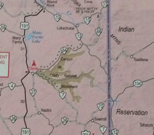
You can stop looking now, it’s not there.
Seriously, stop!
Luckily, it turns out that AAA has a different map for “Indian Country” in all four of the four corners states. It isn’t as detailed, but its purpose is to highlight the features of Indian territory. And thus Tsaile makes an appearance on this map (near the upper right hand corner). Yes, it does. See, it’s right there.
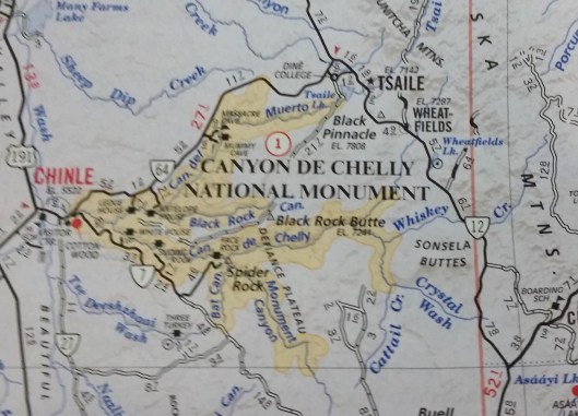
Having seen it here in the “Indian Country” map, you can even pop your eyes back up to the map above and see where Tsaile should have been. No, it’s still not there. You can see where it should be, but it’s not there.
The issue doesn’t seem to be resolution. The Arizona and New Mexico map has a higher resolution than the one for Indian country. I somehow doubt that anyone hatched a plot to hide Tsaile from Ken. My guess, is that the criteria for selecting what to put on each map simply differs, and that the difference was enough to make Tsaile disappear (along with quite a few other things, actually). Luckily Ken found the other map and then found his way to Tsaile.
Okay, so this probably isn’t one of the greater injustices to occur in the all-too sordid history of Indian-white relations, but surely there must be a moral somewhere in this story. It might be just to remember that you can get a separate map for Indian country if your traveling through the area. It could also be that you should get as many maps as you can possibly find, so that you can check them all. Hell, it might even be that you should use your telephone GPS, but that way lies madness!
Frankly, I think the moral of the story is that I’m out of ice-cream, which may seem irrelevant to you, but you aren’t the one jonesing for it right now.
That aside, I’m going for the “get the Indian Territory map if that’s where you’re going” moral to this story. If you want to find your way around the reservations in the four corners, you’re going to want that map.
And with that I’m off to dream of ice-cream.
…or better yet frybread!
I miss frybread.


Great information. Thanks. I once drove hither and thither across the southern part of the Navaho Nation and I have driven from Window Rock all he way across to northern rim of the Grand Canyon. Next on my list is Canyon de Chelly and Chaco Canyon.
You won’t be disappointed. The National Park Service has been in the process of reburying the Chaco pueblos and has nearly destroyed parts of Pueblo Alto, but it’s still well worth the visit — especially at night. If you know where to look, there are still many untouched structures near the better-known population centers.
Be sure to set aside enough time to travel through all of Canyon de Chelly. One day is not nearly enough. If you don’t mind heights, the canyon walls are also interesting. There are still hogans (or were the last time I was there) on the canyon floor.
When you try the frybread, make sure you try the piñon nuts. They’re good with just about everything including pizza.
Still wondering why the Park Service would be reburying them unless they were asked to do so? I have a friend who has friends around all those areas mentioned. I will have to see what she knows.
Pingback: The Dixie Flatline
The NPS is trying to preserve as much as they can, especially from erosion. One of their attempts is to cover areas they think are vulnerable to wear and tear.
Indian Country caught my eye. Then your mention of Dine College–I spent hours one day looking for it. I was meeting a friend to do an education presentation and thought it would be nice to stay in one of the hogan-style dorm rooms that accommodate visitors rather than in a hotel. Although the scenery was beautiful and constantly changing, it was frustrating, even with my Indian Country map, to find the place. Thanks for sharing your map experience. I wonder if Google Maps works better than just asking people for directions on the Rez.
Oh man! That’s two people who had trouble because of the map now. Don’t know about Google maps. Hope the stay itself was pleasant. Did you get out to Canyon de Chelly?
The Four Corners area is beautiful enough that I have been there several times. As for problems with the Indian Country map, it’s better than the state maps. 😀 I think the Native Americans–especially the older ones–get a kick out of lost tourists. The thing is, their directions are fine once you question them about the landmarks they refer to. It’s that so many of the landmarks look alike. 😉
I remember I used to have such a hard time with Navajo directions. Often times people wouldn’t reference roads or even say left or right. Follow-up questions were definitely essential.
Pingback: What Maps Are Not – worldviewsoftware's blog